
Cedar Point
- Mar 6, 2022
- 6 min read
Updated: Mar 7, 2022

Pumpkin Hill Creek at Cedar Point Preserve
Trail Information
Length: Cedar Point Loop: 2.1-mile loop
Length: Cedar Point Loop/Pineland Trails and Side Trails: 4 miles
Time: 2.5 - 3 hours Difficulty: Easy
Cedar Trail Loop Trail Map (trail link)
I am glad you decided to join my team and me on another adventure. Before we get started, I would like to share a health tip I ran across while preparing for this hike.
According to the National Heart, Lung, and Blood Institute: “Devoting some time every day to care for yourself can go a long way toward protecting your heart health. Self-care, like moving more, preparing healthier meals, getting enough quality sleep, and taking a moment to de-stress, helps your heart.”
These tips provided me with additional motivation to increase my activity, which I will discuss further in my next blog. So, if you are ready, let’s go hike!
CEDAR POINT LOOP
My team and I chose to hike the Cedar Point area, located at the south end of Black Hammock Island. It is comprised of 400 acres of wilderness that is part of the Timucuan Ecological and Historic Preserve that connects to a network of trails within the 7 Creeks Recreation Area. These contiguous conservation lands offer 5,600 acres and 30 plus miles of interconnecting trails, creating a nature lovers’ paradise.
The area is highly secluded and ideal for exploring Florida’s native ecosystem in its natural and underdeveloped state. There have been reports of wildlife sightings and over 200 species of birds.
Cedar Point also has a fascinating history and was once the site of Santa Cruz y San Bueneventura de Guadalquini Spanish Mission, established in 1684. There have been archaeological studies to identify the mission’s footprint, which offers insights into how indigenous people lived during our history.
The land on Cedar point was farmed as early as 1783, then turned into a salt production plantation around 1795. We will be visiting the ruins of the plantation later in our hike.
Cedar Point is a multi-use area where you can hike, bike, and fish. If you plan to spend some time in the area, a boat launch and picnic area with a bathroom are also available. We were thrilled to find this remote location, and its wild beauty did not disappoint us.
Start here at Cedar Point Loop.

The trailhead to Cedar Point Loop is located at the very end of Cedar Point Road. We parked in the dirt parking lot, gathered all our hiking gear, and headed out.
We wanted to see Pumpkin Hill Creek, which required us to hike two of Cedar Point's groomed trails -- Cedar Point Loop and Pineland Trail leading to the creek. The course can get confusing due to the side trails and dense forest, so I recommend you download the updated trail map on the link above; I also attached the exact GPS trail we followed during our hike.
Our actual GPS Trail -

Because of the out-of-the-way location, don’t expect to see many hikers; we only met one person on the trail as we were leaving.

Straight Segment of the Cedar Point Loop Trail.
Cedar Point Loop Trail starts with a straight segment before it loops; it is a well-groomed and wide trail, which would also be great for biking. The path is eerily quiet, absent of the familiar sounds of civilization, and shaded with its moss-draped maritime hammock.
As we moved deeper into the forest, our senses were heightened by the anticipation of seeing wildlife that other hikers had reported observing. Ospreys and eagles, white-tailed deer, and even bobcats have been reported to be present on the island. Our binoculars and cameras were ready and anticipating the chance to see and photograph wildlife. Then suddenly, we were surprised by a visitor that was not on our list, nor did we expect to encounter.

The area we encountered the wild hog.
Approximately 5 or 10 minutes into our hike, our attention was directed to the left edge of the trail. There was a loud crashing of branches and a dusting up of dry underbrush, and as we turned to see what the commotion was about, we saw a wild hog race from the trail’s edge into the forest. It was a bit too close for comfort, but I believe the hog was as startled by us as we were by it. We estimated the hog to be close to 200 lbs. We were close enough to see its thick brown and coarse black coat that appeared to be spiked like porcupine quills. Our photographer aimed his camera to capture the moment, but the hog had quickly disappeared into the dense forest. We’re not sure if it was the same hog or his neighbors, but we came across this forest dweller two other times during the hike, and we all kept our distance. I guess they were keeping an eye on the strangers entering their home.
According to a University of Florida publication, wild or feral hogs are not native to America. They were initially brought here by the Europeans and used as domestic stock. Today, they can be found in every Florida county and 35 states.
Pinelands Trail
After we recovered from the adrenalin rush of our hog sighting (I must admit I loved it) and approximately .35 to .45 miles down the straight portion of the trail, there was a fork in the path. Cedar Point Loop continues around the circle and veers off to the left, marked by a blue trail marker, and Pinelands Trail takes you to the right with a red trail marker.

We took Pineland Trail because it is the direction of the bridge and creek; if you are not interested in this side trip, you can stay on the Loop to the left. The terrain instantly changes from an old oak forest to majestic pines on this short trail. As we get closer to the creek, the trail winds through a spectacular view of a salt marsh habitat. Watch for the side trail (on the left) that leads to a well-constructed bridge that crosses over Pumpkin Hill Creek. The bridge is a perfect place to stop, rest, grab a snack, and take photos of the natural salt marsh and gently flowing creek. On the other side of the bridge is Cedar Point Preserve which extends into connecting trails owned by Jacksonville.


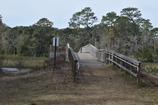


Views from the bridge and pine forest - Photo Credit: Bruce Underwood.
After taking in the view and many photos, we hiked back the way we came and caught Cedar Point Loop to the right, marked with the blue trail marker. The trail follows the loop portion of the hike that leads to the plantation ruins and finally back to where we started. The path is shaded with large Spanish moss-draped trees and an abundance of palmetto bushes. We became dwarfed by the size of these enormous trees and commented that they must be hundreds of years old.


There are many side trails along the way that you may want to take but be aware of ticks and other critters that live in these grassy areas. We felt adventurous and decided to take a side trail that allured us down a narrow path to the muddy salt marsh and creek. As we rounded a tight turn in the trail, we ran directly into an enormous fallen tree with hundreds of oyster shells embedded in its dead root structure. Next to the tree, we saw a large shell mound, and we questioned if it could have been a Shell Midden.
Photo Credit: Bruce Underwood


Side trail on Cedar Loop.
After leaving our fascinating discoveries behind, we returned to Cedar Trail Loop. Approximately three-quarters around the loop is a side trail to the plantation ruins. I
It is hard to imagine that this remote location was heavily farmed as early as 1783. The Fitzpatrick family acquired the land in 1795 and started a salt production operation; then, it was sold to the Browards in 1848. This site once supplied salt to the Confederacy during the Civil War.
The ruins of the plantation's main house, kitchen, and outbuilding, made of Tabby (a concrete mixture made of oyster shells), can be seen at the site. The plantation was shelled and destroyed during the Civil War. (1861-1865)
Photo Credit: Bruce Underwood


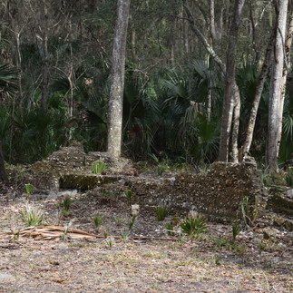
Plantation Ruins
After visiting the ruins, we headed back to the trailhead, and before we left the trail, our wild hog or his buddy decided to say goodbye to us with a snort that echoed from the forest. This hike was one of our favorites so far. We loved the experience of the remote back-to-nature environment and the shift in focus it provided from our everyday life.

Heading back to the trailhead.
Thank you for reading and being part of the adventure blog. We hope you have a fantastic day.
Hiking Tips
· Recommend you only hike this area in the cool months – Insects can be unbearable in the hot weather.
· Be prepared for biting insects, including ticks.
· Wear appropriate hiking gear.
· Check the weather and bring water, snacks, and sunscreen.
· Bring a camera and binoculars to capture those special moments.
· Dogs are welcome but must constantly be on a leash.
Directions from Park Service Website:
From Amelia Island: Take A1A south to the light at New Berlin Road. (You will see a gas station on your left and I-295 one-fourth mile ahead). Turn right at the traffic light and follow New Berlin Road to Cedar Point Road (a triangle intersection). Turn right on Cedar Point Road and follow it, bearing right at Black Hammock Island, continue on Cedar Point Road to the end of the road. The Cedar Point boat ramp will be on your left.
Resources
7 Creeks Recreation Area – Jacksonville, Florida
Credits
Adventure with Purpose Team


Absolutely Beautiful ! Always feel like I’m right there with you!
Thank you for sharing this amazing hike!! I love how you make your readers feel like we are on your hikes with you. I look forward to the next adventure!!🌴
I appreciate the reminder at the beginning that beautiful hikes like this one are important to our self-care mentally and physically. And a jolt from a hog sighting keeps the heart pumping!
Thanks for sharing Leeann, Awesome Place....🐬❤️🐬Mark
This looks like a wonderful place to hike. Thank you for giving such a detailed description and such good suggestions and directions.